
Village Maps
As all Penallt residents know, road names are not used in many parts of the village and house numbers are virtually non-existent, so delivery drivers in particular have a challenging time in tracking down parcel recipients. Those living in the village and their visitors are often unsure of where houses are too.
A few years ago, Prue Evill produced an invaluable map of the village showing the name and location of each house. Peter and Trish Hayward then updated this map to reflect new buildings and name changes and added post code areas. This was further developed in 2020 with the incorporation of a more accurate road map, an alphabetical list of properties and their postcodes.
The maps and index are in three parts:-
Map A: the whole parish, from the Wye in the east to the B4293 in the west, and from upper Whitebrook in the south to the Old Church in the north. The centre contains no house name detail.
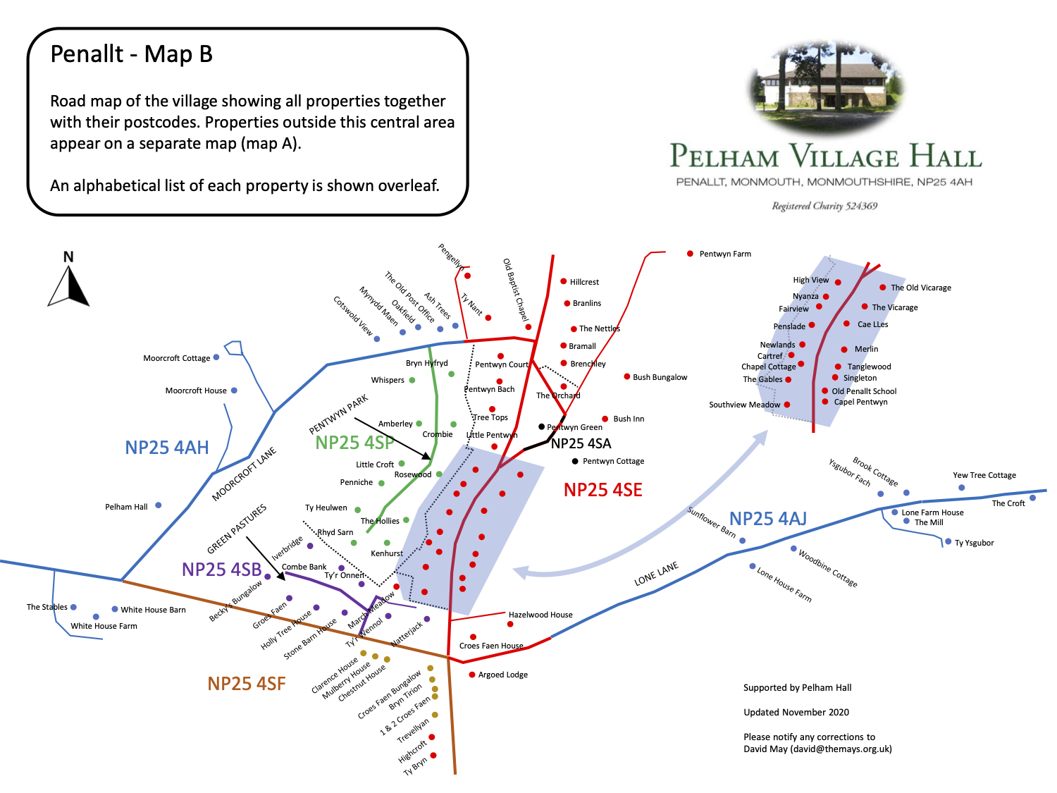
Map B: the central part of the village consisting mostly of houses built in and around the 1970s, together with existing buildings.
Index: Properties listed in alphabetical order with their respective post codes.
Each map may be downloaded via the buttons at the bottom of this page.


Do you know where Pentwyn Lane is?
Delivery drivers find Penallt a frustrating place owing to the inconsistency of road naming in the village. Some roads have no names at all, whilst others have end points which are not well known (e.g. where Glyn Road ends and Lone Lane starts). The recent installation of brand new road name plates has not clarified this either!
Some time ago, Phil Harris sought clarification from MCC and received the following reply, along with some maps:
From the Street Naming and Numbering Officer for Monmouthshire:
I have attached plans showing the names of the roads in the Penallt area. Each one apart from ‘Craig Road to Penallt’ is recorded on the National Street Gazetteer (NSG) as a Type 1 Officially Named record. ‘Craig Road to Penallt’ is a Type 2 Officially Described record, as it holds a description rather than a name it is able to be officially named. The NSG is the definitive source of street names and within Monmouthshire it was compiled using the historic record held by the Council with the primary source being the Highways Register. This Register dates back to the 1940s.
The Emergency Services use Monmouthshire County Council’s Local Land & Property Gazetteer and the street information is all linked up to the NSG.
Royal Mail can cause a few problems when it comes to addresses in rural areas as they very often don’t include the road name in the postal address, their PAF (Postal Address File) is used by the majority of companies and services. Royal Mail will add the road name into a postal address at the resident's request but this will mean a postcode change. This is because the postcode is issued to either a locality or a road, most rural postcodes are issued to localities so this is why you often find one postcode serving a large amount of house in an area.
Here is the link to the Street Naming & Numbering Page, where you can find our Street Naming & Numbering Policy and Appendices that you may find interesting with regards to naming and renaming roads. Royal Mail’s PAF Code of Practice is in the appendices.
The four attached maps have now been aggregated into one larger map below and shows, for example, that the "main road" through the village is called "Pentwyn Lane".
